UK Forecast- May 06, 2024
Dry for many
Getting warmer
 Tuesday
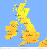
High pressure starts to expand in from the southwest bringing a dry day for many places. Variable cloud and sunny spells. Patchy rain and drizzle for central Scotland in the morning. Scattered showers forming into the afternoon, an odd heavy one for mid-Wales and southwest Scotland later afternoon. Light north to northeasterly breezes. Cool in the northeast, barely 10C on the coast here. Highs up to 17C central England and Wales.
 Tuesday night
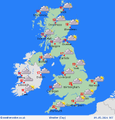
Local showers in the evening fading into the night to be dry for most places. Cloud breaking to leave clearer skies. Some low cloud in the east may spill in across East Anglia. Light winds. Some mist patches forming in valleys. A little light rain reaching western Ireland from fronts over the Atlantic. Temperatures dipping to 5 to 8C.
 Wednesday
High pressure across the British Isles brings plenty of dry and bright weather for most places. Early mist patches soon clearing. Variable cloud and sunshine, best near to coasts by the afternoon. Fronts grazing the far northwest brings some patchy rain to western Scotland and Northern Ireland with a fresher southwesterly breeze here. Highs 14 to 19C, pleasantly warm.
 Thursday
Pressure stays high to the south. Weak fronts drift across Scotland on light westerly breezes with more cloud overall and some drizzly rain mainly in the western Highlands. Dry with sunny spells for most of England and Wales, feeling warm inland. Light winds and sea breezes keeping coasts fresher. Highs 15 to 21C.
|

