UK Forecast- April 29, 2024
Rain for Tuesday.
Turning unsettled with showers later.
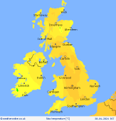
 Tuesday
Further outbreaks of rain are expected over Ireland, western Scotland, western England and Wales through Tuesday, more heavy and persistent over high ground. Further east a drier day with good brightness and sunny spells. A few showers possible over Kent and East Anglia. Breezy with maximum temperatures at 12-14C in north, but reaching 18C in south.
 Tuesday Night
Through the evening and night rain will gradually clear from the west, with only some remaining over western Scotland. Elsewhere dry with clear spells and lighter winds. Temperatures will drop to 6-8C across most areas, but possibly dropping closer to freezing inland over Ireland.
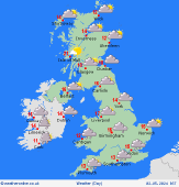
 Wednesday
A mostly dry and bright start to the day with sunny spells especially over the east. Any remaining rain over western Scotland will soon clear away. Through the late afternoon and then through the evening expect more cloud to arrive over England with some heavy and possibly thundery showers spreading northwest. Temperatures will rise put to 12C in north, and 16C in south.
 Thursday
Through the morning expect the heavy and possibly thundery showers to move northwest over Wales and Ireland, with dry weather following on the back with sunny spells. Maximum temperatures at 12-14C in north but up to 16-18C in south.
|

