|
Issued: 1000hrs Sunday 25th February 2018
Duty forecaster: Garry Nicholson
Possible widespread heavy snow later in week
The week ahead will bring the coldest weather Britain has seen for many years. Snow will fall widely, resulting in disruption to travel. Eastern areas will generally see the greatest falls. Temperatures near or below freezing point all week, with severe wind chill. Later in the week, further significant snow is possible as fronts move into cold air from the south, but detail very uncertain.
For the weather for the next few days click here
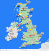 Wednesday 28/02/18 Wednesday 28/02/18
Easterly winds maintain extremely cold weather through midweek. Severe frost overnight, with minimum temperatures -5 to -10C or locally lower in shelter. Further snow is likely, focused on eastern areas, with some prolonged heavy falls possible. Bands of showers over the English Channel may also bring heavy snow to parts of Devon and Cornwall. Daytime temperatures staying sub-zero for some, and only 0 to 2C at best.
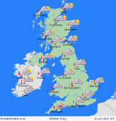 Thursday 01/03/18 Thursday 01/03/18
A continuing very cold easterly pattern. Severe wind chill. Snow in north-eastern Britain, also eastern parts of Ireland. Risk belts of snow also clipping south-west England. Central England and Wales may be dry and bright with hazy sun. Staying near or below freezing by day. Very cold night-time temperatures widely -5C, but risk -10C in some sheltered spots, mainly western regions.
 Friday 02/03/18 Friday 02/03/18
Confidence becomes lower by the end of the week. An area of low pressure encroaching north out of Biscay brings a risk of heavy snow to central, south & south-western Britain and southern Ireland. Less cold air may eventually arrive in the far south, turning things sleety. Cold easterly winds in northern areas, with snow showers toward the east. Most places near 0C, but may lift to 3C south.
Saturday 03/03/18
Low confidence: A risk of sleet and snow for some areas, perhaps becoming rain in the far south, depending on the progress of the less cold air. Generally staying chilly, with a possibility of significant snow locally. Highs 0 to 4C.
Sunday 04/03/18
Low pressure remains toward the south, but a complex weather pattern is likely. A possibility of further snow, perhaps rain in the far south. Highs 0 to 5C.
Monday 05/03/18
Continued wintry problems, but great uncertainty of detail. Risk of snow for some, and rain for others - the less cold air focused on the far south. Highs 0 to 5C.
|
