Morning Call - September 08, 2017
Persistent rain south
Showery north & west

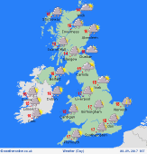
Issued: 0530hrs Friday 8th September 2017
Duty forecaster: Garry Nicholson


Feeling cool, brisk winds on southern coasts

Good morning,

A slow-moving front will reside across central & southern Britain through today, producing outbreaks of rain throughout the day.


The rain is likely to be on and off, but some heavy bursts are likely, and it may persist for many hours at a time in southern counties. A clearance should develop from the west into the afternoon.


Showers will affect the west & north of Britain, some of these heavy and possibly thundery. In Scotland, these showers are likely to be slow-moving where winds are light.

The north-east of England, plus much of Yorkshire and Lincolnshire may fare best overall for fewest showers, and some sunshine breaking through at times.

Fresh west to south-westerly winds will affect southern regions, locally gusting gale force on exposed headlands.

Today's top temperatures will struggle to do better than 14 to 16C, perhaps a little warmer in the east.


Garry


Archive
September
SMTWTFS
          1 2
3 4 5 6 7 8 9
10 11 12 13 14 15 16
17 18 19 20 21 22 23
24 25 26 27 28 29 30
2017