|
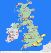 Saturday Saturday
Slack high pressure brings a fair day to most places. Variable cloud, but there should be a good deal of sunshine, best east & north-east. The south-west stays dull with patchy drizzle. Chance of shower by afternoon for central England & Wales. Winds generally light. Fronts bring increasingly persistent rain to north-west Scotland, and a fresh south-westerly breeze. Highs 15 to 19C north-west, 22C Midlands, up to 25C south.
 Saturday night Saturday night
Many places dry overnight, with broken cloud and clear spells. Cloud generaly thickest in the west & north. Frontal rain affects Scotland, most persistent toward the north & west, although a few bursts of rain may reach east of the Highlands before dawn. A fresh south-westerly breeze for northern Britain. Light winds in the south. Lowest temperatures 9 to 15C, warmest south.
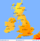
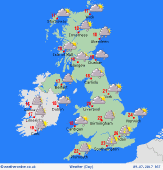 Sunday Sunday
Slack pressure across the British Isles. Variable cloud and some sun. Many places will stay dry all day. A risk of thundery showers breaking out in the south, which may merge into an organised cluster of thunderstorms for south-east England later. Fronts edging southwards bring outbreaks of rain to Scotland & Northern Ireland. Winds mostly very light, breezy in the far north. Highs 16 to 19C north & west, 22 to 25C south & east.
 Monday Monday
Detail is rather uncertain as a shallow area of low pressure resides across central England. A cold front pushes south-eastwards, producing patchy rain in the west & north, which should clear to bring sunny spells later to the north & north-west. Meanwhile, showers are expected to break out across central & eastern England, locally heavy and slow-moving into the late afternoon. A west to north-westerly breeze. Highs 16 to 23C.
|
