|
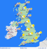 Sunday Sunday
A cold east to southeasterly wind influences the British Isles. Dry overall, with plenty of sunshine. Cloudier in eastern Scotland & north-east England. Snow flurries may develop on eastern coasts of England into the afternoon or evening. Widespread frost, with only slow thawing during the day. Highs 1 to 4C, coldest in eastern counties, and feeling sub-zero where exposed to the wind.
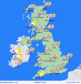
 Sunday night Sunday night
Dry for most places, apart from local snow flurries near eastern coasts. Fairly cloudy in the east & north-east. A easterly breeze continues, strongest near the south coast. Clearer skies in central and western areas. Widespread frost. Temperatures widely below freezing, lows -3 to -5C in sheltered rural areas. Locally lower in parts of Wales and western Scotland.
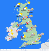 Monday Monday
Bitter easterly winds. Snow flurries for eastern regions, spreading inland toward the Pennines, perhaps also reaching the Midlands. Bands of snow showers around coasts of Kent and Sussex. Snow may well become increasingly persistent in some areas. Generally cloudy. Sunshine best in the west. Temperatures near 0C for most, feeling well below freezing in the wind. Up to 3C in the south-west.
 Tuesday Tuesday
Snow is expected to develop more widely overnight and into Tuesday. A covering is possible almost anywhere. Heaviest falls focused on east & north-eastern areas. Substanial accumulations in some places. The eastern Pennines and Borders are especially prone, plus the North York Moors and perhaps further south into the Peak District and Midlands. Snow will lie to sea level. Highs -1 to 2C.
|
