|
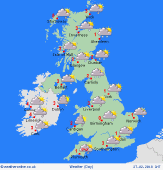
 Monday Monday
Bitter easterly winds, strongest in southern areas. Snow flurries coming in from the North Sea into eastern regions, spreading inland toward the Pennines, perhaps also reaching the Midlands. Bands of snow showers around coasts of Kent and Sussex. Snow may well become increasingly persistent in some areas. Generally cloudy. Sunshine best in the west. Temperatures near 0C for most, feeling well below freezing in the wind. Up to 3C in the south-west.
 Monday night Monday night
Snow is expected to become more organied across east & north-east England and eastern Scotland during the night, turning heavier. Bands of snow showers toward south-east England may give local persistent falls for Kent and Sussex. Snow is likely to spread further inland into central-northern England before dawn. Western area generally dry with some clear skies. Near or below zero Celsius for most, but -5C or locally lower in Wales and the Scottish Highlands.
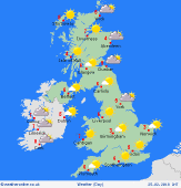
 Tuesday Tuesday
Snow is likely to fall across many areas during the day, the heaviest falls focused on the east & north-east. Substanial accumulations in some places. The eastern Pennines and Borders are especially prone, plus the North York Moors and perhaps further south into the Peak District and Midlands. Snow will lie to sea level. During the day, snow breaking up into showers or flurries. Generally cloudy. Brightest in the west. Highs -1 to 2C.
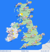 Wednesday Wednesday
Easterly winds maintain extremely cold weather through midweek. Severe frost overnight, with minimum temperatures -5 to -10C or locally lower in shelter. Further snow is likely, focused on east & north-eastern areas, with some prolonged heavy falls possible. Bands of showers over the English Channel may also bring heavy snow to parts of Devon and Cornwall. Daytime temperatures staying sub-zero for many, and only 0 to 2C at best.
|
