|
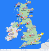
 Monday Monday
A dry and bright day for most of Britain. Fairly cloudy skies for west and northern areas, with localised showers, mainly Scotland, but fading. Sunny spells across the Midlands and south. Brisk southerly winds strengthening for Ireland and western Britain, lighter winds toward the east. Fronts bring rain to western Ireland, turning heavy, later extending to western Scotland. Highs 13 to 17C, warmest south-east.
 Monday night Monday night
Rain advances further into western Britain overnight, heaviest in western Scotland, but also setting in for west Wales and Cumbria before dawn. Staying dry for central, south and eastern England, also the far north of Scotland. Rain on and off for Ireland, breaking up from the west. Strong southerly winds for all, gales around exposed coasts and hills in the west. Staying generally mild, lowest temperatures 8 to 10C.
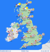
 Tuesday Tuesday
Brisk southerly winds, strongest winds west and north. A cold front lies across western Britain bringing rain to west & southern Scotland, west Wales, also Cumbria, heaviest on south-facing western hills. Patchy rain possible for Cornwall and Devon, whilst a little may drift further onto to the Pennines. Showers for Ireland. Generally dry Midlands and south-east England, some sun. Highs 12 to 15C north & west, 16 to 19C south-east.
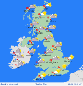 Wednesday Wednesday
High pressure centred toward the east, pushes fronts away to the north and west. Generally dry and plenty of sunshine, best in central and eastern areas. Some western coasts may hang onto areas of low cloud or sea fog. A warm south to southeasterly airflow. Breezy in the north & west, lighter winds and sea breezes south & east. A risk of some rain for western Ireland, but should clear. Highs 18 to 23C, cooler near coasts.
|
