|
 Boxing Day Boxing Day
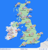
A bright day for many areas, in between weather systems. Areas of wintry showers for northern Scotland, and also around Irish Sea coasts - snow mostly confined to the hills. Cloud breaking to give occasional sunshine. A developing low moves into south-western Britain and Ireland later, bringing heavy rain, turning to snow over Welsh hills, and winds strengthening to gale force around exposed coasts. Cooler than previous days, highs 4 to 8C.
 Boxing Day night Boxing Day night
An area of low pressure moves across southern Britain. A front pivots north-east across the Midlands, bringing heavy rain for several hours, and snow for the hills of Wales, perhaps the Peak District. As colder air gets drawn around from the north, rain may turn to sleet and snow to lower levels in the Midlands. Mainly dry for northern Britain and much of Ireland, with wintry showers on northern coasts. Lows 0 to 4C for many, but sub-zero in Scotland.
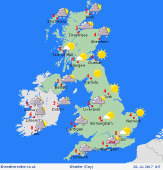
 Wednesday Wednesday
Fronts crossing central England & Wales early in the day bring a spell of rain, or snow over high ground of Wales and the Midlands. Persisent rain and sleet affects eastern England, fading only slowly into the afternoon. Skies brightening from the north. Sunny spells for Scotland and northern England. Wintry showers near coasts in the north & west. Strong northerly winds, gales in the south-east. Chilly, just 2 to 5C.
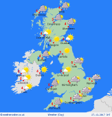
 Thursday Thursday
A chilly north to northwesterly pattern. A bright day for many, with sunny spells and areas of wintry showers - these focused around Irish Sea coasts, running into the Midlands. Snow showers for northern Scotland. Mainly dry in central and southern regions. Some rain may move in from the west later. A frosty start for some areas, with possible ice. Strongest winds in the north-east, lighter winds elsewhere. Top temperatures only 1 to 5C.
|
