|
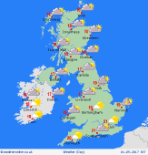 Saturday Saturday
High pressure across Britain brings a fair day overall. Plenty of sunshine and winds mostly light. Sea breezes forming by afternoon. Small risk of a local shower around coasts in the far south-east. A southerly breeze freshening in the west, and fronts moving in from the Atlantic will push rain slowly across Ireland. Temperatures 16 to 19C north & west, locally 20C on the Moray coast. 21 to 23C for south-eastern England.
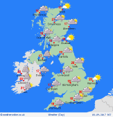
 Saturday night Saturday night
Much of Britain will stay dry overnight, but as fronts encroach across the Irish Sea, rain will develop for western coastal districts, with some heavy falls possible for south-west England before dawn. Eastern Britain may keep clear skies, but high cloud will build from the west. South to south-easterly winds freshening, becoming very windy around western coasts, gales where exposed. Lows 8 to 12C, perhaps colder some Scottish glens.
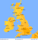
 Sunday Sunday
Eastern Britain stays dry and fairly warm with hazy sunshine. Fronts across western areas bring cloud and rain, with prolonged heavy falls for south-west England & south Wales. Cloudy for central England, with a little rain developing. Rain fading for Ireland. A strong south-easterly wind, touching gale force around coasts in the south & west. Temperatures up to 23C in East Anglia, 17 to 21C elsewhere, but just 13C in rain.
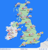 Monday Monday
A weakening front pushes across Britain overnight producing patchy rain for central regions. A humid atmosphere results in a lot of cloud across the country into the daytime, with a little rain locally. Murky with hill and coastal fog in the west & south-west. Western Scotland may see some persistent rain. A south to south-westerly breeze, strongest in the north. Some sun may break through in the east & south. Highs 17 to 22C.
|
