|
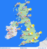
 Wednesday Wednesday
An unsettled day with low pressure in charge. Areas of persistent rain, or snow over high ground in Scotland & Northern Ireland. Zones of constant rain for several hours in northern England too. Otherwise for England & Wales it will be a day of showers, breaking out increasingly by afternoon, these heavy and slow moving. Hail and thunder locally. Winds varied, blustery for some, but very light in central Britain. Highs 6 to 9C north, 10 to 13C south.
 Wednesday night Wednesday night
Clusters of showers continue into the night for central & northern England, snow on hills, becoming confined to eastern districts through the night. Skies will clear from the west. Blustery winds for a few hours, but easing for many later in the night. Mist patches may form in the south-west. Lows 2 to 5C east, but 1 to -2C west & north, locally colder with hard frost some valleys and glens.
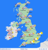
 Thursday Thursday
A better day overall as a ridge of high pressure builds briefly over Britain. A few wintry showers in north-west Scotland. A chance of early brief showers in eastern England but these will clear. A mainly dry day with plenty of sunshine. Cloud building across Ireland as fronts move back in from the Atlantic. Winds west to northwest, then turning southerly and strengthening in the west. Highs 7 to 12C.
 Friday Friday
High pressure to the east promotes a mild southerly airflow across the British Isles. Fronts lying to the west bring rain to Ireland, likely heavy and persistent in the south. Rain or drizzle also affects some western coasts of Britain, where it may turn wetter through the day. Largely dry in central & eastern regions. Fairly cloudy, some hazy sun in the east. Breezy, especially west. Highs 10 to 15C.
|
