|
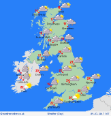 Monday Monday
A slack pressure situation, with fronts drifting slowly south-eastwards. Rain for northern England & southern Scotland in morning. Some heavier showery bursts will pass eastwards across central & eastern England. Slow-moving torrential downpours possible for East Anglia & the south-east, also Scottish Highlands. A few showers Wales & N.Ireland, but often dry. Occasional sunshine. Winds fairly light. Highs 16 to 21C, up to 24C south-east.
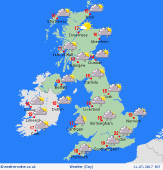
 Monday night Monday night
A complex frontal system drifts into southern Ireland & south-western Britain into the evening, and night, bringing outbreaks of rain, some persistent and at times heavy falls, spreading toward central England by dawn, although rain may be rather fragmented, meaning some places may see very little. Any residual showers elsewhere will tend to fade into the night, but locally rain may linger in Scotland. Light winds. Lows 8 to 14C.
 Tuesday Tuesday
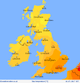
Low confidence of detail: A shallow area of low pressure drifts eastwards across the country. A frontal system influences the south & south-west, which may result in rain for many hours. Rain on and off for central England & Wales. Showery bursts passing east, may turn persistent in the south-east later. Generally drier toward the north, but expect slow moving showers to develop. Winds fairly light, but breezy far south. Highs 16 to 21C.
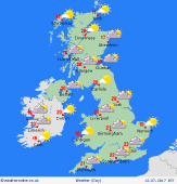 Wednesday Wednesday
A ridge of high pressure builds across the country, bringing a fair day to many places. Good spells of sunshine. Early cloud and patchy rain in the south-east should soon clear. Chance of an isolated shower by afternoon. Winds generally light. Breezy around some coasts, particularly in the south. Feeling fresh, highs 16 to 19C north & west, 20 to 22C south & east.
|
