|
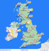 Thursday Thursday
Colder for all on Thursday but with still a lot of dry weather as high pressure continues to dominate the weather. Isolated light showers in the south-east and may be some patchy rain across the extreme north-west of Scotland. Otherwise dry, sunny and chilly with frosty conditions early and late in the day. Highs 2C to 6C.
 Thursday Night Thursday Night
Into Thursday evening and overnight and it will remain dry for much of the British Isles and beneath clear skies it will turn chilly with a likely frost, especially in the countryside. Low risk of a few wintry flurries developing across SE England. Lows -1C to 3C.
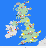 Friday Friday
Increasing confidence that cold conditions will develop during Friday as the easterly winds continue. It brings possible isolated light snow flurries into some south-eastern areas, whilst the north and west should be drier but still cold despite some sunny spells. Winds E'ly for most, perhaps moderate or fresh in the south and east, but still more S or EW'ly in the far west and north-west of the British Isles. Highs at 1C to 4C.
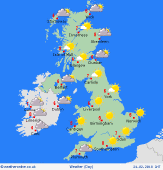 Saturday Saturday
Staying cold into Saturday with a continued east or south-easterly wind. Continued risk of a few snow flurries in south-eastern areas, but otherwise a lot of fine and dry weather with plenty of sunshine through central and northern regions. Significant wind-chill factor, especially across England and Wales. Widespread frost. Highs 2C to 5C.
|
