|
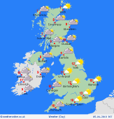 Friday Friday
A pronounced east and west split in conditions will develop through Friday with many northern and western areas of the British Isles becoming increasingly wet and windy through Friday with some locally heavy rain or showers at times and also with a fresh or strong, near gale force S or SE'ly wind. More central and particularly eastern areas of England will have a mainly dry day with some bright or sunny intervals, but windy here too. A mild or very mild day for most, highs 7C to 14C.
 Friday Night Friday Night
Wet and windy weather will continue to slowly move eastwards through the evening and overnight, perhaps becoming slow moving down the 'spine' of the British Isles as the night progresses with some moderate or heavy, rain or showers developing more widely across England and Wales, but still with some drier weather across the far east of England. A mild night, lows 4C to 8C.
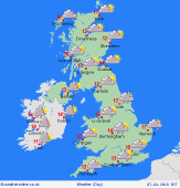 Saturday Saturday
Low pressure currently looks set to continue to dominate into Saturday across most areas bringing a further risk of some rain or showers at times, perhaps initially across England and Wales and also across Scotland. It may start to become somewhat drier and brighter, from the west, through the second half of the day. Highs 7C to 13C.
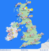 Sunday Sunday
Low pressure is set to continue to dominate the weather through the course of Sunday and while some drier and brighter, if not sunnier intervals are possible more locally and regionally, many areas will maintain a risk of some rain or showers, perhaps especially across more southern and south-eastern areas and perhaps further north and west too. Winds mainly light and variable across many areas. Temperatures not far from average, cooler in the north and west, near or slightly above average in the south and east were mild or very mild. Highs 7C to 13C.
|
