|
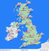 Tuesday Tuesday
An area of rain passing eastwards this morning bringing a wet start to the day in Scotland, northern England, parts of the Midlands, Wales and southwest England. Some cloud and drizzle in the southeast at first, but bouts of showery rain arrive through the morning and into the afternoon. Brighter and drier skies arriving through Ireland and western Scotland this morning, although with some showers too. The drier and brighter weather slips east through the day with many areas turning drier. Highs at 15 to 23C.
 Tuesday Night Tuesday Night
A breezy and dry night for most of the UK and Ireland. There will be broken cloud but some clear spells too. A few showers affecting western areas of Scotland with scattered showers in northern and western parts of Ireland too. Lows at 10 to 14C.
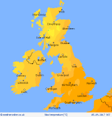
 Wednesday Wednesday
A westerly flow over the UK and Ireland on Wednesday. Higher pressure is to the south with lower pressure to the north. Some showers affecting western coasts and hills, perhaps longer spells of rain at times in western Scotland and northwest England at first, although these fade. Elsewhere it should be dry with sunny spells, the best of these in more eastern and southern areas. A cooler day at 15 to 19C.
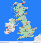
 Thursday Thursday
A fair start to the day as a weak ridge of high pressure passes east on Thursday. This is going to be bringing a bright start with sunny spells, the best in the east and south. Lower pressure west of Scotland pushes fronts eastwards. This will bring wet weather into Ireland and western Scotland with western coasts and hills of England and Wales becoming cloudy and damp as the day progresses. Highs at 13 to 20C.
|
