|
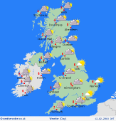 Tuesday Tuesday
Cloudy and wet this morning for many areas. It is going to be cold and that rain will be turning to snow at ties, especially on hills. This could give an accumulation at high levels. Probably drier in the east at first, but windy here with the rain arriving in the morning, turning to snow. At the same time drier and brighter weather arrives in Ireland and western Scotland, with many parts of Scotland, northern and western England as well as the whole of Wales dry with some sunshine developing in the afternoon. A few wintry showers continue to affect western coasts and hills. Highs at 1 to 5C.
 Tuesday Night Tuesday Night
Rain sleet and snow in East Anglia and southeast England at first tonight. Drier weather with clearer skies will be following into the west, although increased winds and more cloud and rain arriving in Ireland after midnight. Lows at -2C but staying above freezing in west Wales, southwest England and Ireland as more cloud arrives here.
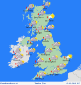
 Wednesday Wednesday
A windy morning as a deep area of low pressure moves to the south of Iceland. Rain in western parts of the UK and Ireland, some heavy, with snow over the hills of Scotland. Starting drier in the east but the rain spreads east into the afternoon. The rain may be heavy again in the west and only light in the east. It stays windy. Showers following into western Ireland with some sunny spells arriving. Cold in the east at 5C but milder air arrives in western parts with tops near 10C on west coasts of Wales and in Ireland.
 Thursday Thursday
A front clears eastern coasts early on Thursday morning taking overnight rain with it. Brighter and colder weather follows from the west with sunny spells for many, the best in the east. Showers may affect western coasts and hills, these falling as sleet, snow and hail. Most of the showers in northern and western Scotland. Winds to gale force in northwest Scotland. Highs at 4 to 8C although these slipping during the day as cooler air moves in.
|
