|
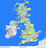 Tuesday Tuesday
A cold front is bringing some heavy and thundery bursts of rain to much of southern, central and eastern Scotland this morning. This rain also affects much of western England and Wales. Drier to the east and south although breezy. Drier and brighter weather follows to western Scotland and Ireland during this morning. The rain band then moves into much of the Midlands, southern and eastern England through this afternoon, although rain generally becomes lighter. Brighter and drier weather continues to follow from the west with sunny spells. Just a scattering of showers into western Scotland and western Ireland. Turning colder as the drier weather arrives too. Highs at 12C in southeast England, near 7 to 9C as the drier weather arrives in the north and west.
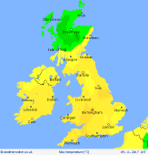 Tuesday Night Tuesday Night
Rain may be affecting East Anglia and southeast England for much of the night. Clearer skies and drier weather will be affecting much of the rest of the UK and Ireland. With clearer skies and lighter winds temperatures will be dropping to allows a frost to form. Western coasts of Scotland and Ireland may see a few showers with no frost. Lows at 1 to 5C.
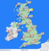 Wednesday Wednesday
The threat of some cloud and a few spots of rain still affecting the far southeast through Wednesday morning as the remnants of a front continue to fade away. Elsewhere many areas start the day chilly and bright and will be staying dry with sunny spells as a ridge of high pressure is maintained. Fronts bring thicker cloud and some outbreaks of rain through Scotland and Ireland as the day progreses. Winds increasing in the north through the day with highs at 7 to 10C.
 Thursday Thursday
Fronts passing eastwards through Thursday. These bring cloud and some outbreaks of light rain and drizzle to much of Scotland and Northern Ireland with an increasing risk of western coasts turning drizzly too. More eastern and southern areas tending to be dry with some bright or sunny spells. Highs at 9 to 14C.
|
