|
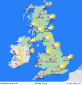 Sunday Sunday
A warm day in the south-east, but fresher elsewhere as winds turn westerly. Areas of rain or showery bursts across northern regions, locally persistent for a few hours, especially in the north-west in the morning. Showery rain passes east across the Midlands through the afternoon, but southern England should escape largely dry. Brightening skies in north-west England, but rain comes back into western Scotland later. Highs 22C south-east, 17C Midlands, 13C north-west.
 Sunday night Sunday night
A scattering of showers for north-western Britain and Ireland overnight, most persistent in western Scotland. Generally dry for central, southern and eastern Britain, with clear spells. A westerly breeze, strongest in the north. Lowest temperatures 7 to 10C, although nearer 5C rurally, and some sheltered valleys may fall a degree or so lower, with slight grass frost before dawn.
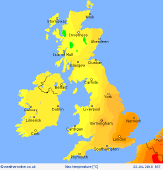
 Monday Monday
Showery in western Scotland from early morning. Fronts coming in from the Atlantic will see rain or drizzle develop across Ireland, then spreading into much of western Britain, most likely in the afternoon. Dry most of the day for central, southern and eastern England, also eastern Scotland. Sunny spells but thickening cloud through the day. A west to south-westerly breeze, strengthening in the west. Highs 12 to 17C, warmest south-east.
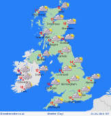
 Tuesday Tuesday
A westerly breeze bring frequent showers into north-western Britain and Ireland, merging into longer spells of rain over the hills, with some heavy bursts. Fewer showers toward eastern and southern Britain. A trailing front may run across southern areas, giving cloudy skies and rain for a time, but tending to clear. Occasional sunshine breaking through. Highs 10 to 16C, warmest south-east.
|
