|
Issued: 0900 Tuesday 14th November 2017
Duty forecaster: Dr. Simon Keeling
A chill weekend after a milder few days, an unsettled start to next week
A mixed and cooler end to the week as northwest wind return bringing a mix of sunshine and showers. Saturday is likely to stay cool, but milder and cloudier weather will arrive in the west with all areas turning milder on Sunday. The early stages of next week now look more unsettled as low pressure passes east, although turning colder and showery again but the middle of the week.
 For the weather for the next few days click here For the weather for the next few days click here
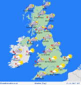
Friday 17/11/17
An area of high pressure builds to the south of Ireland on Friday. Low pressure is a long way northeast of Scotland, but this does turn the wind flow to the northwest for all parts of the UK and Ireland. A cooler day for all with heavy and prolonged showers in northern and western parts of Scotland. The showers turning to sleet and snow on hills. Some showers affecting Northern Ireland and northwest England too. Drier elsewhere with sunny spells but feeling cold in the wind. Highs at 5 to 9C.
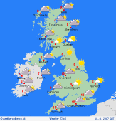 Saturday 18/11/17 Saturday 18/11/17
Low pressure to the east of Scotland, but a ridge of high pressure building through Ireland on Saturday. It is going to be cold for all with showers affecting western, northern and eastern coasts and hills. The showers falling as snow over the hills of Scotland and northern England. Much brighter in central and southern areas with good spells of sunshine. Highs at 6 to 9C.
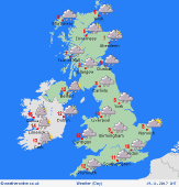 Sunday 19/11/17 Sunday 19/11/17
A ridge in the east of the UK on Sunday, this collapsing away to the east as fronts move into Ireland and the west of the UK. These fronts bringing milder, cloudy, wet and rather misty weather into Ireland and the west of England, Wales and Scotland. Probably drier in the east and south of England and Wales, but still chilly here and turning increasingly misty and murky later. Highs at 5 to 7C in the east, 10 to 12C in the west.
Monday 20/11/17
An area of low pressure crossing the UK on Monday and moving into the North Sea. Cloud and rain associated with the low passes east, some of the rain could become heavy. Breezy for some to. Mild in the south, but colder weather arriving from the north as the rain steadily clears. Highs at 7 to 13C.
Tuesday 21/11/17
Low pressure deepens once again to the west of Ireland on Tuesday. Drier further east for a while with a ridge of high pressure here. Wetter and cloudier weather in the west with increased winds as the low pressure arrives. Highs at 7 to 14C.
Wednesday 22/11/17
The area of low pressure is expected to pass east on Thursday. This brings cooler northwest winds to all with a mix of sunshine and showers. Most showers to the north and west. Highs at 5 to 10C.
|
