|
Issued: 1000hrs Thursday 9th November 2017
Duty forecaster: Garry Nicholson
Snow showers north; some frosty mornings
Cold north-westerly winds will affect the British Isles this weekend, bringing sunshine and wintry showers. Snow will chiefly affect the mountains, but in northern Scotland snow may fall and lie to low levels. A frosty Monday morning is likely. The rest of the week looks changeable, with some wet weather at times. The longer range outlook suggests wintry conditions may return later in November.
For the weather for the next few days click here
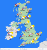 Sunday 12/11/17 Sunday 12/11/17
A chilly but bright day for many places. Bands of showers spreading from the north, affecting eastern coasts, and also moving inland from the Irish Sea toward north-west England, north Wales and the Midlands - wintry over higher ground, perhaps snow or hail briefly to lower levels. Northern Scotland will see frequent snow showers, giving accumulations to quite low levels. Brisk north to north-westerly winds. Highs 5 to 8C, but feeling closer to zero in the wind.
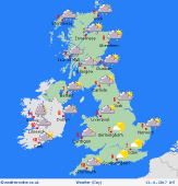 Monday 13/11/17 Monday 13/11/17
As winds drop overnight, a widespread frost will develop - near or below freezing for many to start Monday. However, it will be bright with plenty of sunshine. Cloud will tend to thicken from the north-west as fronts move in from the Atlantic. Rain developing for western Scotland & Northern Ireland, later becoming more widespread, preceded by snow on the mountains. A south-westerly wind will freshen. Temperatures rising slowly to 6 to 9C.
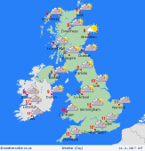 Tuesday 14/11/17 Tuesday 14/11/17
A zone of rain will advance south-eastwards across Britain overnight and into Tuesday. Residual rain may be slow to clear from southern England, but brighter skies should follow for central & northern regions. A few bands of showers are possible toward the north-west, which may again be wintry over the Scottish mountains. A west to north-westerly wind, possible gales for a time in the English Channel. A little milder at 7 to 12C.
Wednesday 15/11/17
The remains of previous fronts may affect southern and central regions, bringing a risk of cloud and outbreaks of rain. Northern Britain & Ireland look brighter with some sunshine. Fairly light winds, with possible fog and frost in the morning. Highs 8 to 12C, mildest in the far south.
Thursday 16/11/17
Timing is uncertain later in the week, but wet and windy weather may encroach in from the Atlantic. Heaviest rain is likely to affect western areas, whilst the south & east may escape drier and fairly mild. Risk of gales developing. Highs 7 to 13C.
Friday 17/11/17
Some uncertainty, but looking quite unsettled, with periods of rain or showers for many places. Blustery winds, locally gale force. Showers may turn wintry again on northern hills. Highs 7 to 11C.
|
