|
Issued: 1000hrs Friday 10th November 2017
Duty forecaster: Garry Nicholson
Rain at times, mostly west
A surge of Arctic air will once again encompass the British Isles over the weekend. Temperatures will stay in single figures, with a significant wind chill. Monday morning will start frosty for all. During next week, milder air gradually arrives from the south-west, with some rain at times. A changeable pattern is likely toward next weekend. Chilly weather looks set to return later in the month.
For the weather for the next few days click here
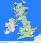 Monday 13/11/17 Monday 13/11/17
A widespread frost to start Monday morning. However, it will be a bright day with plenty of sunshine. Cloud will tend to thicken from the north-west as fronts move in from the Atlantic. Rain developing for western Scotland & Northern Ireland, later becoming more widespread, preceded by snow on the mountains. Winds turning from north to south-west, dropping light for a time, but strengthening in the west later. Temperatures rising slowly to 6 to 9C.
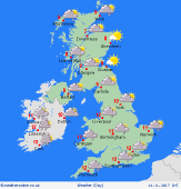 Tuesday 14/11/17 Tuesday 14/11/17
A zone of rain will advance south-eastwards across Britain overnight and into Tuesday. Residual rain may linger across central-southern England & Wales, but brighter skies should develop for northern Britain. A few bands of showers are possible toward the north-west, which may again be wintry over the Scottish mountains. A west to north-westerly wind, possible gales for a time in the English Channel. A little milder at 7 to 12C.
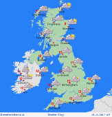 Wednesday 15/11/17 Wednesday 15/11/17
The remains of previous fronts may drift back northwards as milder air pushes in from the south-west. Cloudy with outbreaks of rain or drizzle, mainly in the west. Northern Britain & Ireland may be brighter with some hazy sunshine. Fairly light south-westerly winds, with possible fog and frost for northern areas in the morning. Highs 9 to 13C, mildest in the south.
Thursday 16/11/17
Timing is uncertain later in the week, but wet and windy weather is expected to encroach in from the Atlantic. Heaviest rain is likely to affect western areas, whilst the south & east may escape drier and fairly mild. Risk of gales developing in the north-west. Highs 9 to 14C.
Friday 17/11/17
Slightly cooler as a cold front passes eastwards. A period of rain followed by showers, most frequent in the north-west. Little rain may reach the south-east. Blustery west to south-westerly winds. Highs 8 to 12C.
Saturday 18/11/17
Detail is uncertain. A changeable pattern is likely with westerly winds bringing areas of showery rain, most frequent in the west & north. Highs 7 to 12C.
|
