|
Issued: 0900 Wednesday 14th February 2018
Duty forecaster: Dr. Simon Keeling
A mixed start but then dry and cld through the weekend and into next week
An unsettled couple of days ahead but then a major change in the weather takes place into the weekend. Higher pressure builds bringing plenty of dry weather. The drier weather lasts into next week although it may well be turning colder by the end of the forecast period. The risk of some snow flurries in the east later.
 For the weather for the next few days click here For the weather for the next few days click here
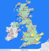
Friday 16/2/18
A ridge of higher pressure building through England and Wales on Friday. This gives a mainly dry day with broken cloud and some bright or sunny spells. A front extends through Scotland and into Ireland giving cloud and outbreaks of rain and drizzle. There's litle change during the day with the rain staying in Ireland and western Scotland but other areas being dry. Highs at 5 to 8C.
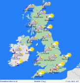 Saturday 17/2/18 Saturday 17/2/18
Low confidence in the forecast from Saturday. A northeasterly flow develops in southern areas bringing a few spots of rain in the Midlands and eastern England, although there is uncertainty over exactly where this frontal cloud will be. Some rain and drizzle in northwest Scotland as a warm front passes east. Drier elsewhere under a ridge of high pressure. Highs at 3 to 6C.
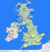 Sunday 18/2/18 Sunday 18/2/18
High pressure centred over the south of the UK and Ireland on Sunday. Fronts may bring some cloud and outbreaks of rain and drizzle to northern and western Scotland. Elsewhere mostly dry and fair with sunny spells, although some morning mist and fog patches in England and Wales. Tops at 4 to 7C.
Monday 19/2/18
High pressure may be over the UK and Ireland on Monday. This should be bringing a fair amount of dry weather with good spells of sunshine in western areas. The east may have more in the way of cloud and a few wintry showers. Highs at 5 to 8C.
Tuesday 20/2/18
High pressure is expected to be over the UK and Ireland on Tuesday, although a brisker northeast breeze develops. This is likely to be bringing cloud and some outbreaks of drizzle and rain to eastern coasts, whilst western areas stay dry with some decent spells of sunshine. Highs at 5 to 8C.
Wednesday 21/2/18
A much colder day seems in evidence for Wednesday as the easterly wind brings that cold weather in from the continent. The risk of some snow flurries in the east, but drier and brighter west and north. Highs at 2 to 5C.
|
