|
Issued: 0930 Tuesday 7th November 2017
Duty forecaster: Matthew Hugo
Rain moves east through Tuesday, changeable after that, but then colder into the coming weekend
Active weather fronts head east through the rest of Tuesday, locally heavy rain in places. Mixture of drier intervals, but with some further wet weather, especially in the north and west through the rest of the week, but then colder and showery into the weekend, especially in the north and east.
 For the weather for the next few days click here For the weather for the next few days click here
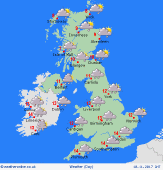
Friday 10/11/17
Fronts move south through the course of Friday bringing some rain and showers, perhaps locally heavy in the west for a time, expected to clear the south into the afternoon and evening. Following on behind Coler weather arrives in northern Scotland as the rain clears, although there will be showers here. Highs at 6C in northern Scotland, 13C in southern England.
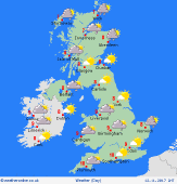
 Saturday 11/11/17 Saturday 11/11/17
A colder northwesterly flow develops on Saturday as high pressure builds west of Ireland with low pressure to the east. There will be showers in north and west initially, but with the greatest risk of showers then transering to more northern and eastern areas later in the day, perhaps wintry on northern hills too. Many central and southern areas of the UK though having a lot of dry weather with some good sunny spells. Overnight frost is likely. Highs at 6C to 11C.
 Sunday 12/11/17 Sunday 12/11/17
Another chilly day, after a possible frosty start, with high pressure to the west and low pressure to the east. There will be further showers, most on northern and eastern coasts and hills with some wintry over the high ground of Scotland and eastern Pennines. Scattered showers affecting northern and western coasts of Wales too. Dry elsewhere with sunny spells. Highs at 5 to 10C, widespread frost set to develop on Monday night.
Monday 13/11/17
A ridge of high pressure builds into Ireland and the west of the UK through Monday with a morning frost for many. Low pressure to the east allows for the northerly flow to bring scattered showers in the far east and southeast. Drier to the northern and west with sunny spells, although cloud may increase in the far northwest of Scotland and western Ireland. Highs at 7C to 10C at best.
Tuesday 14/11/17
Fronts bring increasing cloud through the north and west on Tuesday with some rain at times, perhaps especially across W Scotland and N Ireland. Drier in the east and south with bright spells after a morning frost. Highs at 8C to 11C.
Wednesday 15/11/17
Uncertainties over the details, but weak fronts potentially moving southwards through the day bringing some rain and showers, but perhaps with the far south and south-east of England remaining mainly dry and rather chilly. More pronounced wet and windy conditions may arrive across northern and western areas later in the day. Highs 8C to 12C
|
