|
Issued: 1125 Sunday 16 July 2017
Duty forecaster: John Ejdowski
Hot and humid mid week
Overall weather conditions will be quite unsettled for this upcoming week as high pressure gives way to deep low pressure. The area of low pressure is expected meander around Ireland and western parts of Britain right through until perhaps the end of the weekend when pressure starts to build in from the west. Temperatures are generally expected to be above normal.
For the weather for the next few days click here
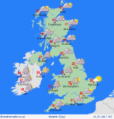
Wednesday 19/07/17
A hot and humid day to come and very windy across the north. Heavy, thundery rain across northern England and Northern Irelands moves north affecting Scotland and Northern Ireland through the day. Some rain and showers to come across England and Wales but brighter and mainly dry across East Anglia and the south east. Mostly cloudy overnight with a few showers. Expect highs of 19 to 28C.
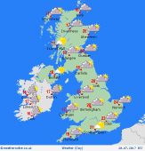
 Thursday 20/07/17 Thursday 20/07/17
Fresher weather is expected today. It continues unsettled across Britain today with a good deal of cloud, sunnier spells and showers. Fewer showers to come across Scotland. Cloudy overnight with a pulse of rain running in across south west England and Wales. Expect highs of 17 to 21C.
 Friday 21/07/17 Friday 21/07/17
Friday continues unsettled. Many areas start fair and dry but showers across the south west in the morning may become more widespread across Britain later in the morning and through the afternoon. Many of the showers could be locally heavy, merging into longer spells of rain. Showers die out in the evening then dry overnight. Look for highs of 16 to 22C.
 Saturday 22/07/17 Saturday 22/07/17
Little overall change is expected across much of Britain with plenty of showers, some heavy, throughout the course of the day. Again these perhaps merging into spells of rain in the south. Expect highs of 16 to 20C.
Sunday 23/07/17
Most areas begin the day fair and dry but a number of showers again tend to develop for the afternoon, though these not as widespread or as heavy as previous days. Any showers soon fade early in the evening. Expect highs of 17 to 21C.
Monday 24/07/17
With an area of high pressure ridging in from the west, much of the United should have a more settled, dry day with the best of the sunshine away from western coasts. Later some rain may reach north western parts of Scotland later in the day. Look for highs of 18 to 24C.
|
