|
seiten=6 abk=aweekahead
A mild, wet and windy spell, then colder
Mild, wet and windy conditions set to dominate for most in the coming days, but turning colder later this week and into the coming weekend in particular.
For the weather for the next few days click here
Thursday 23/11/17
The strong winds lessen but still a windy and mild day for England and Wales, but turning colder across N England as the day progresses. Mostly cloudy with scattered showers, these mostly in the north and the west. Colder for Scotland with wintry showers over the hills. Further rain and showers to come overnight with snow perhaps down to lower levels across northern Scotland. Windy. Expect highs of 6C to 14C.
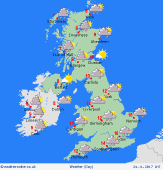
 Friday 24/11/17 Friday 24/11/17
Colder conditions are set to filter southwards to many areas through the end of the week at the moment with a mixture of sunshine and showers, these most frequent across the north, west and east, locally wintry on high ground anywhere from N England northwards and locally to lower levels across Scotland. Winds NW'ly moderate fresh and all areas, especially England and Wales, feeling colder than previous days. Highs near 5C to 10C.
 Saturday 25/11/17 Saturday 25/11/17
Colder weather is set to continue with further showery conditions, wintry across northern areas, especially on higher ground but to lower levels across Scotland. Confidence is low, but there may well be an area of low pressure moving east across parts of England and Wales through the day, outbreaks of rain may turn briefly to snow, this over high ground in the south. Expect highs of 4C to 8C.
 Sunday 26/11/17 Sunday 26/11/17
A cold N or NW'ly wind will maintain a rather cold period of weather for all areas with morning frost certainly possible and then a day of sunshine and showers, these most frequent around the periphery of the UK and, again, wintry on higher ground in particular. Highs around 4C to 8C.
Monday 27/11/17
Low confidence but potentially turning wet from the west through the day as longer spells of rain arrive and this perhaps falling as snow, initially at least, across more northern areas. Windy weather possible and temperatures 6C to 11C.
Tuesday 28/11/17
There are signs of a potential renewed N or NW'ly wind towards the end of November, so, at the moment at least, colder weather may well filtering southwards across many areas through Tuesday with an on-going risk of rain or showers and these increasingly wintry once again across northern high ground in particular. Windy and feeling cold, temperatures 4C to 9C at best.
|
