|
Issued: 0900 Monday 3rd July 2017
Duty forecaster: Simon Keeling
Mixed with thundery showers and feeling very warm at times
A mixed week ahead and one which is likely to be very warm or even hot on a few days. This heat triggers thundery showers, some of them heavy especially in the west. Rainfall amounts will be sporadic though with some areas drier than others. Hints of becoming a little fresher nest week with stronger winds in Scotland.
 For the weather for the next few days click here For the weather for the next few days click here
Thursday 6/7/17
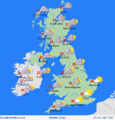
High pressure remains to the east of the UK on Thursday. A trough in the west is going to allow for some thundery bursts of rain, extending from southwest England, through Wales, northwest England and into Scotland and Ireland. These storms may bring some heavy bursts of rain. Eastern areas of England should stay dry with some sunny spells. Muggy for all with highs at 23 to 29C.
 Friday 7/7/17 Friday 7/7/17
A slack pressure flow across the UK and Ierland on Friday. Thundery showers fade in the early hours with most places seeing broken cloud and some bright spells on Friday morning. More persistent rain affecting northwest Scotland as a front approaches. The afternoon sees some thundery outbreaks of rain developing in England, Wales and Scotland with more scattered showers in Ireland. A very warm day for most with highs at a hot 30C in southern England, 20C in northern Scotland.
 Saturday 8/7/17 Saturday 8/7/17
The slack pressure flow continues through Saturday. Some thundery rain may affect parts of Ireland and western Scotland with a few thunderstorms also forming in eastern England later. Elsewhere drier with some sunny spells. Cooler in much of Scotland at 15C, but a very warm day in England, wales and Ireland with tops of 23 to 29C.
Sunday 9/7/17
A ridge of high pressure builds eastwards on Sunday. This should bring a mostly dry day with sunny spells. There is a risk of a thundery showers in southern England and perhaps some spots of rain in northwest Scotland. Tops at 16 to 26C.
Monday 10/7/17
Fronts passing northeast across Ireland and Scotland on Monday bringing cloud, drizzle and some periods of rain here. Drier to the south and east with sunny spells here, the best in the east. Highs at 18 to 24C.
Tuesday 4/7/17
Staying dry in the east and south as a weak ridge of high pressure continues ot influence the weather here. A band of cloud and rain spreads south through Ireland and Scotland, where it may be windy too. Showery rain in northern England and Wales. Tops near 14 to 23C.
|
