|
Issued: 0900hrs Thursday 7th September 2017
Duty forecaster: Garry Nicholson
Risk of gales
An active jet stream over the north Atlantic will drive a series of low pressure systems across the British Isles during the week ahead. Frequent bouts of wind and rain are expected, with a threat of gales in exposed areas on some days.
For the weather for the next few days click here
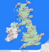 Sunday 10/09/17 Sunday 10/09/17
A bright start in the south & east of Britain, but any sunshine soon turning hazy as cloud builds from the west. Rain already affects Ireland first thing in the morning, and soon spreads into western Britain. Through the middle of the day, rain is likely to move quickly into central areas, reaching the south-east during the afternoon. Heaviest falls will be over western hills. Strengthening winds, local gales west. Highs 13 to 18C.
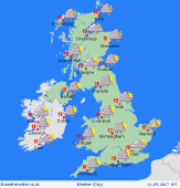 Monday 11/09/17 Monday 11/09/17
A windy day for all as low pressure passes across northern Britain. A cool north-westerly flow brings pulses of showery rain, merging into some longer periods of rain at times in the north & west. Most places will see showers through the day, although there will be bright or sunny spells at times. Blustery winds, locally gusting gale force. Temperatures just 12 to 17C, warmest south-east.
 Tuesday 12/09/17 Tuesday 12/09/17
Pressure briefly builds overnight, bringing a dry and cool start for many. Another developing low is expected to spread in quickly from the west, bringing wind and rain to Ireland, then moving into western Britain through the day. Heavy falls of rain setting in across Wales and western England. Eastern counties may escape dry for many hours before rain develops later. Winds increasing again. Highs 13 to 19C.
Wednesday 13/09/17
Timing is uncertain, but a cold front is likely to sweep east across the country, bringing a spell of heavy rain. This will clear from the west, but heavy showers will follow, and these merging to longer periods of rain in the north-west. Windy, possible gales across northern Britain. Highs 13 to 18C.
Thursday 14/09/17
Detail uncertain: The wind is likely to turn north-westerly as low pressure moves away eastwards. Sunshine and showers for many, although these may fade in the south-west as pressure builds. Blustery again, and feeling cool. Highs 12 to 17C.
Friday 15/09/17
Confidence is low: Another low may move across northern Britain, producing further wind and rain, although southern regions may escape drier. Highs 13 to 18C.
|
